Wednesday, 4 October 2017

West Highland Way Trail in Scotland

And, too, the heavy trudge of boots
which used to stamp upon it in pursuit
of sheep or cattle. Or else stumbling back
homewards just before the black 
of night consumed the borders of a bog
stretching wide before soles, the perils of a loch,
perhaps, where a neighbour drowned. Sphagnum moss, 
above all, stores the footsteps of those who are now lost,
those residents and denizens of moor
for whom moss feels an absence, their drum of feet
no longer pounding desolation like a heartbeat any more. 
----From a poem by Donald S Murray


The West Highland Way
is an iconic walk in Scotland steeped in history with constantly changing beautiful scenery; it is also the longest in Scotland, starting in Milngavie, a suburb of Glasgow and ending at 96 
miles (154 km) muscle aching, feet hurting, but proud, in Fort William. The trail meanders along some of the most breath taking terrain in the Highlands, taking in varied landscapes of lochs, highlands, forests, bubbling burns and waterfalls.
A well marked trail
where convoluted turns are marked by posts bearing the logo of the West Highland Way, a thistle within parenthesis.  Most of the Way is along old military roads, also known as General Wade's Military Roads.  These were made in the 18th Century to move troops to quell local rebellion. The roads are well defined but rough and may result in blisters or a sprained ankle if one is not careful.There are many climbs and descents and one of the more rugged stretches is the one that traverses the Devil's Staircase - an 850ft (259m) climb that is written about ominously in most blogs.  Though it's a sustained zig-zag climb, it's not nearly as brutal as the name would suggest.


Loch Lomond- the Northern end
The trail is doable by any reasonably fit person, our group ranged from 40's to a sprightly gentleman of 80, all of whom did the walk.  Walkers come in all shapes and sizes, greyhounds at a mile eating trot eager to "bag" the trail, walk fast, listen to music, tick off the box as trail done and breathlessly talking of when they “conquered so-and-so trail”.  At the other end are sloths like me who waddle along smelling the roses, taking a zillion photographs and simply absorb being there. In between these extremes are runners, cyclists and campers. The trail has been run in less than 14 hours but the usual is what we did, an easy 7 days of walking averaging 22 km per day.  The trail can be done in sections separately or continuously as we did, choose what suits you best.
Under the Railway

There are various ways to do the walk, we did it supported by an organiser, Thistle Trekking who did everything but hike for us. They were flawless in that they booked accommodation and moved heavy baggage ahead, provided guides and took care of all the logistics. So all we had to do was walk with a daypack. The other extreme way of doing the Way is camping in designated areas and completely self-supported. Along the trail we saw many campers carrying massive loads and waltzing along, setting up at the many beautiful campsites along the Way. 
The iconic Bridge of Orchy
Along the Way we walked by spectacular scenery, the desolate Rannoch Moor, the huge Loch Lomond, imposing Glencoe Mountains, the historic Bridge of Orchy.
 It is also a Way along some of the historic places of the Highlands. Rob Roy’s cave on Loch Lomond, the site of many battles and the lore associated with them, St Fillan’s Priory and swords of legend.  There are informative boards at these places describing historical events.

Clad for lashing rain
The weather fluctuates as much as the terrain does, from a bone chilling cold wind to an energy sapping hot sun and back again, all in a few hours. Pray that the weather smiles else these can be a miserable and wet 7 days. We were lucky in having only one day of  heavy rain, on this day the wind and rain combined to make it very wet. The other cloudy and cool days were great walking days. We dressed in layers taking off and putting on with almost irritating regularity.  
An interesting section of Trail

Details of equipment required and suggested itineraries have been described in various blogs and articles on the net. So I will only emphasise what I feel is important, nay, vital for an enjoyable walk. If it interests you read my earlier blog on appropriate gear titled The Fashionate Trekker.  The military roads are broad and well defined, but uneven and roughly cobbled stone and inappropriate footwear can result in very painful soles and blisters.   Comfortable walking/hiking boots well broken in and water-resistant, (emphatically do not wear athletic or soft soled running shoes) and appropriate socks,  will make for happy feet, and happy feet are essential for this walk. Good rain gear and comfortable daypack come next. The midges in summer can drive you crazy, literally, so a headnet and/or repellent is a must.
Flora and Fauna
The heavy rainfall, rugged hill sides, lack of succulent feed, allows for little flora and fauna on the hillsides.  Thistle in a variety of shapes and sizes, grows everywhere. The Scottish cow is quite unusual in that it has a fringe across the face, possibly defence against the maddening midges. Like this little Robin redbreast, birds are mainly near civilisation, cadging a morsel and protection from the elements.This is a very wet area and seeds possibly left by a bird on a fence-post have germinated into these ferns and a flower; while a cow in the background is, unusually, kneeling and feeding.  I saw signposts at many places indicating the habitation of deer, but did not see a single one.  The guide told us said that in summer the deer go into the higher reaches to feed and escape the ubiquitous midges.
A bridge in a lush green forestThe streams always had little wooden or stone bridges such as these. The terrain we walked through was immensely varied, the lush, thick, green forests where trees and boulders are covered in moss, with many waterfalls and streams, to ..... 
...The vast flat emptiness of Rannoch Moor
Said to be one of the largest Moors in these parts, it follows a long glen between the highlands. It is very wet and boggy, making it very inhospitable and precluding any habitation.  I carried a camera to supplement the snapshots I took on my mobile when it was wet.  When trekking  with a camera I always make sure I have a comfortable means of carry, this time a cross shoulder strap that I had made myself; waterproof cover, and I mean "water proof" as water can quickly kill a camera. I had a spare battery and memory card and just one lens, a  Fuji 18-55mm kit lens. Simply remember, each additional gram on a long trek is going to seem like a kilo.  For a more detailed blog on trekking with a camera see my earlier blog The Trekking Photographer 

In all thy moods I love thee,
    In sunshine and in storm;
Lochaber of the towering bens,
    Outlined in rugged form.
Here proud Ben Nevis, snowy crowned,
    Rests throned amidst the clouds;
There Lochy's deep and silvery wave,
    A royal city shrouds;

---From a poem by Alice MacDonell

Thursday, 6 July 2017

Amboli - Dancing in the Rain


"life isn't about waiting for the storm to pass,
It's learning to dance in the rain."
 Amboli is a deluge in June, (it rains an average of seven metres per year) and coupled with lush forests, it is the ideal environment for a host of insects, amphibians and snakes. All celebrating the monsoon in their own way, quite literally singing, dancing, mating and eating in the rain. About an hour from Sawantwadi station on the Goa/Maharashtra border, probably the resort is protected by its inaccessibility as one can only get up by road. 
Room with a view
We stayed at Mrugaya, a small but very comfortable homestay run by Parag Rangnekar.  It has three rooms, very neat and clean, with a large verandah and sit out. The Parag is also a very talented nature guide with prodigious knowledge of the local flora, fauna and trails.  His patience and pleasant demeanour add to the experience. Eat at the many restaurants in the town, if you are non-veg the fish thali is particularly delectable and ....cheap. 
Nature's cycle
The monsoon in Amboli is a time of great amphibious activity, There are frogs and toads everywhere, they congregate around the tiniest of puddles in the forest, attracting mates and feeding. Though mainly in puddles, they also climb trees sitting on wet leaves and singing. I had been here last year, later in the season, and saw a very different stage in the lives of denizens of the forest.
The Malabar Gliding Frog is arguably the star of the show. This is the time for mating and they do so lustily.  A fountain in the forest department park nearby is a haven for this brilliant green and red frog. Many naturalists who come this time of year do so for the Malabar Gliding Frog, they are easily seen and the mating ritual is on.  They first mate, then foam and finally lay eggs in the slightly sticky foam, usually on leaves or trees.  
In full cry..
Every puddle, bush or tree has frogs calling in them, t
heir chorus is jungle music, from tiny typewriter clicks, to guttural cries of the toads and the eerie, almost bird-like, call of the night frog or nyctibatrachus.  The pouring rain drains along the side of the road and into ponds and streams, each populated with its frogs or toads.  Most males have a vocal sac which gets distended when they call, some of them, like the one in the lower picture above, have two sacs.  This enables them to serenade prospective mates and make a sound far greater than their size would suggest.
Petitioning the Lord....
About 45 minutes from Amboli there is a very scenic and beautiful plateau, a vast expanse of laterite rocks, interspersed with grass and water bodies. The plateau is dominated by a solitary temple and the drive to the area is attractive in all seasons particularly monsoons and winter. On the way there the road meanders along a river, paddy fields, tracts of karvi plants and expanses of laterite rock.Towards the end of the monsoon, the entire area is carpeted with tiny flowers making a beautiful sight.


Tadpoles feeding
This is a time for fertility, and every puddle, even the tiny ones, are teeming with life.  These tiny tadpoles, barely the size of one's thumbnail are busy feeding in a roadside puddle. There are myriads of them, initially shy they would skitter away under water plants, however, they soon got used to our presence and continued their non-stop feeding. They need a constant food supply to enable them to be adult frogs before the end of the monsoon.

The Amboli Toad or Tiger Toad
Arguably unique to this area, particularly the plateau, the Amboli Toad is a timid but beautifully striped amphibian. Due to the limited geographic spread of this toad a special effort needs to be made to ensure it's preservation. One can see them almost at every step, from small juveniles to larger ones, the best place to see these beautiful creatures is around the water puddles in the laterite rock of the plateau.
Colourful rain protection
It rains very heavily at this time of year, almost a non-stop deluge with very brief  lulls in between. The wind too is violent, particularly in open spaces around the plateau. The locals make traditional rain protection from leaves, to which have been added a modern and colourful twist of plastic sheeting, the result is a dry and warm protection.  These ladies are herding buffaloes which are feeding off to the left of the picture.
The hunter and the hunted
Here is a leaf-nosed bat, a grasshopper on the laterite plateau and an inquisitive frog that climbed a stump to get a better view of us....  Amboli abounds in interesting nature, The entire food chain is beautifully existent, from the hunter to the hunted. Insects are plentiful, on them feed the frogs and others (geckos, calotes etc), these in turn are rich pickings for the snakes and bats. 
Snakes and scorpions
A herpetologists delight, the forest has many different types of snakes visible at this time of year. Drawn by an abundant food supply, This time we saw the Malabar Pit Viper in  (green and brown morph here)and the Green Vine Snake.  On my last trip I saw a catsnake envenomating a calotes (for a picture see my Flickr album The Eyes of Nature).  Scorpions too feed on the many small frogs, tadpoles and the insects found here.
Interesting insectsThere are insects of many shapes, sizes, colours and stages of their lives here. A walk in the scrub and ruins around is always rewarding in the beautiful sights and sightings. The rulers of Sawantwadi, the Bhosale's, have a decrepit summer home here, it is in ruins.  But in these ruins and forest around there are bats, geckos and many insects.   Sometimes just walking around the mansion and its grounds, imagining things as they would have been in their heyday, is therapeutic.

Rain...
As Dolly Parton famously said:
"The way I see it, if you want the rainbow, you gotta put up with the rain."
It rains heavily in Amboli but it also offers a rainbow of colours, in its flora, fauna and seasons.  There is something for everyone all the time.

Thursday, 6 April 2017

Parvati Valley - snow clad mountains and smoke


The Parvati Valley
Is one of the lesser known valleys near Kullu, however at the beginning there are prominent places like the hot water springs at Manikaran and Kasol, a smoky destination for the Great Indian Tourist.  The areas served by a road are perpetually full of tourists seeking easy reach and harder stuff.  On the other hand the places where one has to walk to are beautifully calm and isolated. 
A sketch of the Valley
A schematic sketch shows the Burshaini bowl, the road goes upto Tosh whereas the other villages are on foot tracks. If one wants solitude, then walk...  There is a large dam being constructed across the Parvati river at Burshaini, I wonder how this will affect the ecology when this is completed. 

Khalga under snow
I found just the village - Khalga which was off the beaten track. Early March offers a very different experience, it had snowed a day prior to my arrival and a carpet of white covered everything. It was cold, most often bitterly so, and some of the treks I did were in knee deep snow or ice. The head of the Parvati Valley is in a bowl surrounded by snow capped mountains. The bowl has Burshaini and Tosh, both served by roads; and Khalga, Pulga and Tulga, three villages on the mountainside are reached walking.
Every house a homestay or 'guest house'
This seems one of the main sources of income for local people.  In anticipation of the impending season, hectic work was on to clean, refresh or add a room or two to each home stay. The whine of power tools often pierced the tranquillity. A homestay can be a single room with a toilet outside in the snow, toilet down the corridor or an en suite toilet.  The rates for each varied as per the location and conveniences offered.  In the smaller places, like Khalga where I was staying expect to pay about Rs 500 for a very comfortable room and a toilet down the corridor. Homestay owners can get friendly and offer services far beyond what one pays for, and at many locations I saw long term associations where guests kept coming back year after year.


Fickle weather and Fresh Snow
It had snowed heavily just before I arrived and on the drive up the hillside was covered in snow. The weather was as fickle as the people were friendly. Of the six days I was there it rained or snowed on three. Generally the pattern was clear, bright, sunny mornings and wet evenings. The clouds would rise by mid afternoon and rain/snow by evening.


Cafes Everywhere
The season heralds a flurry of activity in preparing cafes, every trail, be it snow bound or the back of beyond, has a cafe. these are ubiquitous huts of wooden skeletons covered in brilliantly covered plastic; these served the mountain cafe staple of 'magi noodles', omelettes
, chips and chai. A menu I have seen almost wherever I have trekked in the mountains. The food here and in homestays is basic but very tasty. In my homestay I made a deal with the host to provide me local food for lunch and dinner.  The menu usually was rajma-chawal, puri-sabji, dal-chappati, with egg bhurji thrown in sometimes to add flavour. Here we see a husband and wife carrying chairs and mattresses to their cafe and the Sun Flower cafe at the start of the Kheerganga climb. Many cafes offer more than food and drink.

Walking in the snow
In the mountains it is wise to spend the first day just getting used to the altitude, walking in the snow and braving the cold. It may not be high altitude, but from sea level (Mumbai) to 3000m in about 24 hours needs reasonable precautions. It had snowed heavily the day before my arrival, and the landscape was shrouded in snow.  The sun is far sharper at this altitude and the reflection from the snow adds to this. I took a guide who knew where to go and the alignment of paths; sometimes ponds and streams are covered in snow and the unwary hiker can end up having a swim at -5°C. 

Icicles on the rocks
It was cold in March, early morning temperature dipping to -5°C or colder.   Each morning when I went out for a walk, the frost would crunch underfoot and the puddles were frozen over. It is important to dress in layers as per dictates of the weather, on any given day I would start out bundled in my warmest wear, gradually removing layer by layer till I was in a single warm T-shirt at midday.  As evening approached I would be in rain gear and clad in my warmest again. The icicles on the way made interesting patterns on the rocks.
Track to the Waterfall
...and on to Kheerganga. There are two routes to Kheerganga, one Khalga-Waterfall-Cafe and Kheerganga and the other Dam-Nagthan village-Rudra Nag Temple-Bridge and on to Kheerganga. I did  not go to Kheerganga as due to the fresh snow and ice, the route was very slippery and I feel, dangerous. So I walked to cafe by one route and returned by another, a hike of about 12 km. The route to the waterfall was snow and ice covered, and the waterfall was frozen, with beautiful icicles suspended from the rocks around. 


Waterfall at Rudra Nag Temple.
I took the Rudra Nag- Nagthan way back from Cafe.  From the cafe the path drops down steeply to the bridge on the Parvati river, a slippery and icy track and shortly thereafter is the Rudra Nag temple with a gushing waterfall nearby. This side of the valley has much less snow and ice, probably due to the increased exposure to the sun.  This is also possibly the reason that it has more population.
 
Children playing at a bonfire at Nagthan
This is a large village on my route back, this route has more ascent and descent than the route out. I had to descend twice to the river and climb up again.  Whereas the route from Khalga was more or less along the same height and more scenic. 
Lady soaking in the sun at Nagthan
as soon as the sun went low, it became cold and everywhere I saw people soaking in the warmth of the last few rays. Nagthan too had its share of homestays, most very basic. If one is to go to Kheerganga it might make sense to stay here the first night.

Mountains around Tosh
Tosh is served by a road and much more on the beaten track. It is a popular weekend destination for young kids from Delhi and Chandigarh, hence it is more touristy, more expensive and does not have much solitude. Booming trance music and smoke emanate from most homestays. It is also the start for the four or five hour Kutla trek, I am told that the high altitude Kutla meadows are tranquil and beautiful, alas I got to know too late and did not go.
Main street Tosh
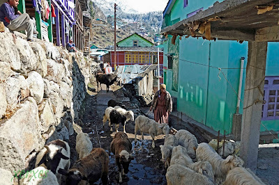
the melting snow made most paths slushy and wet, particularly if a herd of sheep or cattle had used it. There was mud everywhere and sometimes ankle deep. The village paths everywhere were veritable streams and it was important to have water resistant boots  and carry a spare set of socks all the time.
Snow, solitude and bare trees
March in the Valley is beautiful, the Great indian Tourist is yet to descend in hordes, there is a lovely biting nip in the air, there is solitude to be found off the beaten track 
and the people are not so busy yet and have the time to be friendly.  Bare plum, apricot and apple trees strech their arms out to snow covered mountains over which huge Griffon and Golden eagles soar effortlessly.  

Sunday, 19 February 2017

Airoli Creek

The Skyline on the banks of Airoli Creek
Located in the suburbs of Mumbai, Airoli Creek is a wide tidal creek, flanked by mangroves teeming with life, but the concrete march threatens to annihilate the mangroves and with them all that is attracted to these mangroves. 
 
Sunrise at Bhandup Pumping Station
BPS is a perennial waterbody surrounded by scrub, bushes and mangroves, thus one sees a wide variety of birds. There is a small waterway that leads from here to the main Airoli Creek which is flanked by mangroves.
An inquisitive cormorant
There are waterbirds and scrubland birds, particularly in winter when migratory birds come in, passing through or destination. On one morning recently we saw 46 types of birds, some resident and many migratory.
A Pair of White Cheeked Bulbuls
Residents here, there are many bulbuls around BPS.  The marshes around are always wet, being tidally fed and a walk through them is messy and difficult but always interesting. The high humidity here is evident in the water droplets on the plants all the time.
Flamingos of Airoli Creek
A destination for flamingos for long, Airoli Creek has many flocks, each in their hundreds. These huge and lovely birds feed on the rich nutrients in the soft mud of the tidal creek. When disturbed they get airborne, initially ungainly as they have to literally "walk on water" to get their huge bodies up into the air..... 
...But once in the air
they are graceful, perfectly aerodynamic flying fast and purposefully.  I wonder how long they will keep coming to Airoli considering the concrete onslaught. Buildings have  come up to the water's edge and the mangroves are always threatened
The mangroves
survive only because naturalists raise their collective voices when the builders suggest razing the mangroves in the interests of "progress".   Though mangrove is a collective term, there are many species of plants that constitute the dense marshy forest and a study of these is interesting in itself
A black headed Ibis
offers a silhouette on the little creek leading from BPS to Airoli, this is a threatened species. In this waterway one sees many different types of birds, varieties of ducks, ibis and many other water birds.
Mumbai's effluence
This is the creek that leads from BPS to Airoli Creek, I wonder how long it will be before even the birds wrinkle their noses in disgust at the garbage in the water, each of those white spots in the picture above is a plastic bottle or thermocole plate. BPS has become a 'tourist' destination where each morning on weekends droves of people descend to the jetty for a boat ride to see the flamingos. These boatmen make the flamingos fly for the entertainment of their passengers, these lovely birds are disturbed from their feeding every few minutes. It will be little wonder if they stop coming.
Idyllic waterway
It is not too late, never too late, we need to get our act together to preserve this little corner of Eden.  It doesn't take much, some regulation to prevent boatmen and tourists from constantly disturbing birds, control garbage and save the mangroves. Mumbai needs its lungs and this is one of them.