Showing posts with label forest. Show all posts

Sunday, 1 July 2018

Who Says There are No Flowers in the Valley of Flowers?

A sign at the Entrance to the Valley of Flowers (VoF) says it all
The passionate forest guard at the gate told me that he had been scolded by a senior officer that the VoF had no flowers, and that he, the forest guard, should put up a sign warning everyone so.   The experience I had was entirely different, I saw a myriad flowers blooming and a tranquil Valley.  And I thought to myself that: 
they are really blind those who will not see. These flowers were very different to to those I had seen on my earlier trip in August 2015, view my photographs of the earlier trip at the link here and my blog of that trip over here
Flowing water everywhere
A kilometer after buying a ticket at the forest check post, I cross the steel bridge across the Pushpawati River and begin the ascent into the VoF. The ticket is valid for three days of which I will visit on two.  The mountainsides are striated with waterfalls fed by t
he melting snow, which in turn feed streams, all flowing into the Pushpawati River.
A Glimpse of Snow
From the dark depths of the entrance across the bridge, I get a fleeting view of the snow clad mountains that rim the VoF.  The 
deeper ravines are initially dark, in the shadow of  the tall mountains around, but the sun suddenly illuminates the dark valleys, a spectacular natural light show accentuated by the sharp clear mountain air. 
Blue Poppies
Another forest guard walking by, told me that the rare Blue Poppy had begun to bloom along the way, and almost as soon as he said it this lovely plant came into view on a rocky hillside. Had he not told me, I could have easily missed this cluster as did many others walking by.
Fragile and Translucent petals
make the Blue Poppy a rare sight to behold. Blooming at only a few rocky places, one needs to know where they are to be able to enjoy their delicate beauty.  This flower is the signature plant of the area.

The Path to the Valley
When I had come to VoF in  August 2015, I was told that a major flood and landslide the previous year had caused the path to be realigned.  At that time the path had been mud which the August rains had turned to a glutinous morass. Now it is paved with meticulously laid rocks which allow the water to drain through easily.  It is an easy climb up to the Valley.
An Inquisitive Pika  
feeds on grass while watching me. There are many of  this large mouse looking animal living in the rocks along the way.  They are bold and as I stand still they come quite close.  The fur is brown and grey, with some of them having a distinct line where the colour changes, probably a thick winter coat changing to a lighter summer one.  I saw many birds, Blue Whistling Thrush, Variegated Laughing Thrush, Himalayan Bul Bul are some I could not identify.  There are the elusive Red Fox and bear in this area too.
Flowers Everywhere
Spring has come to the Valley and the flowers are blooming, predominantly blues and purples. I admire the view on a bright and sunny day over breakfast at Shepherds Rock, eating packed puris and sabzi that I am carrying from the GMVN guest house where I am staying.  This is possibly the neatest and most reasonably priced staying option in Ghangariya.
Small Flowers and Big Flowers
Ghangariya is the base from where I do my trips to VoF and Hemkund sahib.  It is at the base of two Valleys, each of which lead to either Hemkund sahib or VoF.  This year the tourist season seems less but remains crowded with pilgrims, tourists, mules, porters and many others.
Single and in Bunches 
There is an intermittent mobile signal here, mainly BSNL, but no data connectivity.  The market has many STD booths (I thought those were history!) from where one can call outwards.  The electricity can go off sometimes so make sure that your phone and camera batteries are charged at all times.  The weather has been delightful, bright and sunny every morning, with very light showers on two afternoons. A late lunch of parathas and sabzi  again at Shepherds Rock.
By the side of the path and ....
At one end of town the horses and porters line up and in the morning they waylay me.  I take a mule to Hemkund Sahib, but walk twice to VoF.  The mule I hire to take me to Hemkund eyes my rather portly frame with a resigned look, but takes me up and down rather uncomplainingly.  There are government rates for everything so one has to haggle only a little.
... on it, the stones along the path are interspersed with these little violets
There are fresh blooms and dried tall plants, presumably the relics of last year. The forest department hires people to continuously remove weeds from the Valley as these are said to threaten the indigenous flowering plants.
Who said there are no flowers?
The flowers bloom and whither in hours, days and at most two weeks. I did two hikes over 48 hours and saw Angelica buds the first time and blooms the second.  Other flowers had begun to grow, and some were slowly fading.  I don't know or remember the names of the flowers I saw, I simply reveled in their beauty. The typical 'season' is July-August, but  at this time too there are many flowers.  On my previous trip in August 2015, I saw many different flowers, clearly indicating that one must visit the Valley in different seasons
.
Mount Ratavan in the distance
is at the head of the Valley, at the lower reaches of this mountain is the Tipra Glacier, and below that is the 'Tipra Khark', presumably the moraine. The entire Valley is about 8 kilometers long after entering and one can walk to the end, but that has to
be a single minded purpose, as time does not permit one to smell the roses and walk to the end. From Ghangariya the total distance would be about 11 km each way. One can enter the VoF at 0700 and must be out by 1800 hours, overnight stays are not permitted.

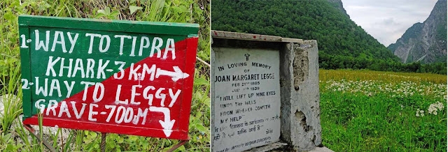
Signboard on the way 
put up by the forest department indicates the bifurcation for 'Tipra Khark'  and Lady Joan Margaret  Legge's grave memorial  (Leggy as she is known here).  In 1939 Joan Margaret Legge was studying the flora of the Valley of Flowers  while traversing some rocky slopes she slipped and lost her life. Her sister created this memorial/tomb to her. The Valley is at an average height of about 3500 metres, this is high altitude and it is smart to be acclimatised, particularly if you are going up from sea level as I was.
The Path to the River
Though I could not walk to the 'Tipra Khark', on my second visit to the Valley I did some photography and then walked  to the river crossing. About 2 km short of the 'Tipra Khark'  the Pushpawati River crosses the Valley, over here the ground is more rocky and there are less flowers.  The entire path is paved with stones which have sharp edges and points, at the end of a 15 km round hike, the soles of my feet were sore.
Farewell to the Valley
as I recross the bridge to return to Ghangariya, I have to be out of the Park by 1800 hours and the gate is about a kilometer away. The water in the river has risen as the snow in the higher reaches has melted during the hot and sunny day, I stop for a few more photos before hurrying on my way...  
At the gate I meet my friend the forest guard and he asks me "so, did you see any flowers?" I think the dreamy smile on my face tells him all.
Flowers don't worry about how they're going to bloom. They just open up and turn toward the light and that makes them beautiful.     
-Jim Carrey


Tuesday, 24 January 2017

Karnala - Thumbs Up to the Nature World


Beacon to nature lovers and trekkers far and wide.
Located just off the National Highway Mumbai-Goa, the central basalt rock pillar of Karnala Fort, often referred to as 'Pandu's Tower', is visible from great distances. I saw it close while up in the air flying by in a helicopter, picture here. It was then I decided to climb the fort.

An encouraging 'Thumbs Up' 
Generally built on two levels, the landmark pillar is at the higher level of the fort which is at a strategic location guarding the Bor Pass.  It has changed hands many times and Marathas, Portuguese and the British have all in turn held this important fort. Today it is far more peaceful, beckoning birders, walkers and picknickers from afar.  There are two distinct aspects to Karnala, a climb to the fort itself and nature trails in the forests around.


The Climb
The trek to the fort starts at the forest office complex inside the park gates. It is about an hour's moderately stiff climb for the fit, an hour and a half for couch potatoes like me. Initially it is a vertical climb along a clearly discernable but very uneven path consisting of  steep steps, roots and boulders.  The walk is through thick forest in the lower reaches, part of the bird sanctuary where one sees a variety of birds and troops of langurs and macaques. 

Along the Ridge
After climbing uphill for a while, one reaches a pass, where the path turns right along the ridge to the north of the fort. The wily builders to the fort had ensured just one approach along a narrow ridge, this ensured that the attacker could not concentrate sufficient  troops to storm the fort, making it easier to defend.
Approaching the fort
The ridge is about a kilometre long, with beautiful views on both sides. While walking towards the fort one can see the dense forest of the sanctuary on the west (right) and the Patalganga river in the distance to the east (left). The path is not in good repair and large parts are cross-country rough terrain. The vegetation to both sides of the path has been burn by the forest department to 'manage' the growth.
Calotes
This calotes tries escaping the heat of the burning vegetation.
The forest department takes great 'trouble' to keep the path clear, I saw an official, supervising a gang of labour who simply burnt the grass and small vegetation on the sides of the path.  Ever wonder why there is a constant haze everywhere?  This random burning doesn't care for the little animals and insects that are killed, the large living trees that are burnt and of course the possibility of the fire spreading.
At the main level
There are walls that denote structures of yore, but these seem more European in shape, possibly added on later by the Portuguese or British. The stories these stones could tell if they could talk!  These could be barracks for the defenders or powder magazines for the cannons.  The cannons deployed here could not have been very large as there seems to be no large path to get them up, also as is evident from the small embrasures in the walls.
An empty gate stares
Flanked by two trees, an empty gate opens out to what may have been the main approach to the citadel. There appears to be signs of a larger path below it, now unusable. Behind the gate are rock-cut cisterns.  Water was the lifeblood of these forts, and they had to have a sufficient stock of water to withstand long sieges of months or even years. These cisterns were rain fed or filled by springs.
Stairs to a lookout
These stairs go to a lookout at one end of the fort, there is a steep unguarded drop on either side. Most forts such as these based their defences on inaccessibility, the more difficult to climb or gather large forces, the easier to defend. So often the attacker had only one recourse, the siege, these lasted months or even years. 
Karnala Bird Sanctuary
The eponymous bird sanctuary, surrounds the base of the fort. The slopes are thickly wooded, providing residence to a variety of birds, insects and mammals. An early morning walk along the trails is a rewarding one, allowing glimpses of the denizens going about their daily lives.  Beware weekends, as a little later in the day, a very destructive species of the Great Indian Picnicker strikes these cool and silent forests. Throwing thermocole plates with gay abandon and catcalling, they quickly destroy the environment and solitude of these wondrous forests.
Forest Trails
There are many trails in the forest of the sanctuary, the longest takes about an hour of slow walking. One can combine trails, switch trails midway or do them sequentially. Some trails have grasslands and most have forests astride them.  Besides the ever present macaques and langurs, one can see a variety of birds and insects depending on the season.
Sunrise
My favourite time in the forest is when the sun rises, actually the sun rises behind the fort hence becomes visible in the sanctuary to the west much later. The rays are highlighted by the smoky haze of early morning inversion.  The effect is ethereal. 
Drop of gold
The sun backlights this dewdrop, the drop is so clear that it acts as a lens, reflecting the forest behind it. 
As the rays peep over the fort, they slowly percolate the forest canopy, warming plants, insects and birds. The best time to photograph insects is when they are slow before being warmed by the sun.
Breakfast
This is one of the best times to see birds as well as they are busy in their early morning feed or on tops of trees soaking in the sun. Here is a green bee-eater with a tasty grasshopper morsel. Behind is a sunbird, well ... sunning itself!
Salmon Arab Butterfly
Butterflies are plentiful, and as it gets warmer, they get more active, so go early for good pictures. On my many walks here, I have seen some amazing sights real close. It is nice to see the serious effort put in by the forest department in preventing litter  I hope it is not a losing battle, as unless we discipline ourselves, we shall end up neck deep in a pile of paper plates and plastic bottles.  Worse, I have seen birds snared in plastic bags and people feeding monkeys non-monkey food.
Lemon Pansy
I recommend spend a day going up to the fort and another half day walking the trails.  each has a lot to offer.  Don't miss breakfast and lunch at the little cafe inside the park, run as a cooperative by local ladies, they offer veg and non-veg food, both delectable.  The glutton in me orders the non-veg thali accompanied by the vegetable of the day, getting the best of both worlds. 
Spending a day or two, specially mid-week, in and around Karnala is a true communion with nature. 

Wednesday, 12 November 2014

Meghalaya - a Sojourn in the Clouds

The abode of the clouds, so aptly named.  Do not go to Meghalaya with a plan for a hectic ‘been there done that’ kind of schedule crammed with plans for sight seeing.  This is a state which you have to just soak in ( pun intended); rambling through verdant hills, waterfalls and lakes.  The beauty here is a vivid green kaleidoscope of forested hills, water and clouds.

One can arrive at Guwahati by train or plane and then motor up to Shillong, the capital of the state.  This town used to be the capital of Assam in the old days and the layout and buildings are still redolent of the Raj. Using Shillong as a base one should motor around the state as far afield as one desires.  There is plenty of accommodation in Shillong ranging from the budget friendly to the exotic and expensive.Bungalows in Shillong

The three hour drive up from Guwahati is a precursor of scenes to come, lush green rain forests, and quaint villages with huts that have woven bamboo walls. It is sad though also to see the number of land slides along the way, possibly caused by deforestation. In winter this far East, the sun sets very early, when we went in November by 4.30 pm it was dark, so if you go in the afternoon, much of the beauty is lost in the darkness, to truly enjoy this lovely drive start early.
Don Bosco Museum


Spend a day or two in and around Shillong. There’s the Don Bosco museum and the Butterfly Museum (a privately owned collection),Wards Lake is a nice spot for a stroll. The Police Bazaar is the socially happening place, stroll around and watch a delightfully eclectic fusion of ethnic and west both in music and in dress. Watch the sunset from the Shillong Peak, a view point at the Air Force station, go early as it is a 40 minute drive and there is a crowd to have passes made. Going early also allows time for spectacular panoramic views of Shillong.
Umiam Lake


Spend a day on and around Lake Umiam, 20 kms from Shillong, this vast lake offers a truly serene experience. There is a facility for water sports, but I recommend you find the slowest boat possible and soak in the ambience.  On an island in the lake there is a hotel and house boat, it appears to be the ideal ‘get away from it all’ spot. Many hotels line the shores of the lake, all very scenically located.  We found the Ri Kynjai to be spectacular, both in the views it offered and the entire interiors done in local crafts, primarily cane and bamboo.
Khasi Handicrafts
The hotel buildings have been inspired by the local Khasi architecture. Have lunch here, it is worth every penny of a slightly up market meal. For a bit of culinary adventure, try the Khasi food.


On the way to Sohra

Every one has heard about Cherapunjee, the wettest place on earth; just that we somehow landed up there in its driest month!  Locally known as Sohra, it is a scenic three hour drive to reach there. The terrain and vegetation varies sharply depending on the rainfall patterns.  One passes thickly vegetated hills and valleys as well as starkly barren and flat plains in a seemingly random pattern. Do carry lunch as facilities are few and far between. In Cherapunjee there are many view points from where to see the cloud veiled cliffs which drop sharply down into Bangla Desh. 
On the way to Sohra

The best view is from Thangkharang Park where a walk around the rim of the cliff affords magnificent views. In the rainy months the water falls here would be breathtaking, the dry months are Jan, Feb, Nov and Dec. The limestone formations inside Mawsmai cave merit a visit, though not for the claustrophobic; carry a torch though. 

Green and serenity is the theme of a visit to Meghalaya, enjoy the ambience, flora and calm of one of the least troubled of the North Eastern States.