Showing posts with label trekking. Show all posts

Wednesday, 4 October 2017

West Highland Way Trail in Scotland

And, too, the heavy trudge of boots
which used to stamp upon it in pursuit
of sheep or cattle. Or else stumbling back
homewards just before the black 
of night consumed the borders of a bog
stretching wide before soles, the perils of a loch,
perhaps, where a neighbour drowned. Sphagnum moss, 
above all, stores the footsteps of those who are now lost,
those residents and denizens of moor
for whom moss feels an absence, their drum of feet
no longer pounding desolation like a heartbeat any more. 
----From a poem by Donald S Murray


The West Highland Way
is an iconic walk in Scotland steeped in history with constantly changing beautiful scenery; it is also the longest in Scotland, starting in Milngavie, a suburb of Glasgow and ending at 96 
miles (154 km) muscle aching, feet hurting, but proud, in Fort William. The trail meanders along some of the most breath taking terrain in the Highlands, taking in varied landscapes of lochs, highlands, forests, bubbling burns and waterfalls.
A well marked trail
where convoluted turns are marked by posts bearing the logo of the West Highland Way, a thistle within parenthesis.  Most of the Way is along old military roads, also known as General Wade's Military Roads.  These were made in the 18th Century to move troops to quell local rebellion. The roads are well defined but rough and may result in blisters or a sprained ankle if one is not careful.There are many climbs and descents and one of the more rugged stretches is the one that traverses the Devil's Staircase - an 850ft (259m) climb that is written about ominously in most blogs.  Though it's a sustained zig-zag climb, it's not nearly as brutal as the name would suggest.


Loch Lomond- the Northern end
The trail is doable by any reasonably fit person, our group ranged from 40's to a sprightly gentleman of 80, all of whom did the walk.  Walkers come in all shapes and sizes, greyhounds at a mile eating trot eager to "bag" the trail, walk fast, listen to music, tick off the box as trail done and breathlessly talking of when they “conquered so-and-so trail”.  At the other end are sloths like me who waddle along smelling the roses, taking a zillion photographs and simply absorb being there. In between these extremes are runners, cyclists and campers. The trail has been run in less than 14 hours but the usual is what we did, an easy 7 days of walking averaging 22 km per day.  The trail can be done in sections separately or continuously as we did, choose what suits you best.
Under the Railway

There are various ways to do the walk, we did it supported by an organiser, Thistle Trekking who did everything but hike for us. They were flawless in that they booked accommodation and moved heavy baggage ahead, provided guides and took care of all the logistics. So all we had to do was walk with a daypack. The other extreme way of doing the Way is camping in designated areas and completely self-supported. Along the trail we saw many campers carrying massive loads and waltzing along, setting up at the many beautiful campsites along the Way. 
The iconic Bridge of Orchy
Along the Way we walked by spectacular scenery, the desolate Rannoch Moor, the huge Loch Lomond, imposing Glencoe Mountains, the historic Bridge of Orchy.
 It is also a Way along some of the historic places of the Highlands. Rob Roy’s cave on Loch Lomond, the site of many battles and the lore associated with them, St Fillan’s Priory and swords of legend.  There are informative boards at these places describing historical events.

Clad for lashing rain
The weather fluctuates as much as the terrain does, from a bone chilling cold wind to an energy sapping hot sun and back again, all in a few hours. Pray that the weather smiles else these can be a miserable and wet 7 days. We were lucky in having only one day of  heavy rain, on this day the wind and rain combined to make it very wet. The other cloudy and cool days were great walking days. We dressed in layers taking off and putting on with almost irritating regularity.  
An interesting section of Trail

Details of equipment required and suggested itineraries have been described in various blogs and articles on the net. So I will only emphasise what I feel is important, nay, vital for an enjoyable walk. If it interests you read my earlier blog on appropriate gear titled The Fashionate Trekker.  The military roads are broad and well defined, but uneven and roughly cobbled stone and inappropriate footwear can result in very painful soles and blisters.   Comfortable walking/hiking boots well broken in and water-resistant, (emphatically do not wear athletic or soft soled running shoes) and appropriate socks,  will make for happy feet, and happy feet are essential for this walk. Good rain gear and comfortable daypack come next. The midges in summer can drive you crazy, literally, so a headnet and/or repellent is a must.
Flora and Fauna
The heavy rainfall, rugged hill sides, lack of succulent feed, allows for little flora and fauna on the hillsides.  Thistle in a variety of shapes and sizes, grows everywhere. The Scottish cow is quite unusual in that it has a fringe across the face, possibly defence against the maddening midges. Like this little Robin redbreast, birds are mainly near civilisation, cadging a morsel and protection from the elements.This is a very wet area and seeds possibly left by a bird on a fence-post have germinated into these ferns and a flower; while a cow in the background is, unusually, kneeling and feeding.  I saw signposts at many places indicating the habitation of deer, but did not see a single one.  The guide told us said that in summer the deer go into the higher reaches to feed and escape the ubiquitous midges.
A bridge in a lush green forestThe streams always had little wooden or stone bridges such as these. The terrain we walked through was immensely varied, the lush, thick, green forests where trees and boulders are covered in moss, with many waterfalls and streams, to ..... 
...The vast flat emptiness of Rannoch Moor
Said to be one of the largest Moors in these parts, it follows a long glen between the highlands. It is very wet and boggy, making it very inhospitable and precluding any habitation.  I carried a camera to supplement the snapshots I took on my mobile when it was wet.  When trekking  with a camera I always make sure I have a comfortable means of carry, this time a cross shoulder strap that I had made myself; waterproof cover, and I mean "water proof" as water can quickly kill a camera. I had a spare battery and memory card and just one lens, a  Fuji 18-55mm kit lens. Simply remember, each additional gram on a long trek is going to seem like a kilo.  For a more detailed blog on trekking with a camera see my earlier blog The Trekking Photographer 

In all thy moods I love thee,
    In sunshine and in storm;
Lochaber of the towering bens,
    Outlined in rugged form.
Here proud Ben Nevis, snowy crowned,
    Rests throned amidst the clouds;
There Lochy's deep and silvery wave,
    A royal city shrouds;

---From a poem by Alice MacDonell

Thursday, 6 April 2017

Parvati Valley - snow clad mountains and smoke


The Parvati Valley
Is one of the lesser known valleys near Kullu, however at the beginning there are prominent places like the hot water springs at Manikaran and Kasol, a smoky destination for the Great Indian Tourist.  The areas served by a road are perpetually full of tourists seeking easy reach and harder stuff.  On the other hand the places where one has to walk to are beautifully calm and isolated. 
A sketch of the Valley
A schematic sketch shows the Burshaini bowl, the road goes upto Tosh whereas the other villages are on foot tracks. If one wants solitude, then walk...  There is a large dam being constructed across the Parvati river at Burshaini, I wonder how this will affect the ecology when this is completed. 

Khalga under snow
I found just the village - Khalga which was off the beaten track. Early March offers a very different experience, it had snowed a day prior to my arrival and a carpet of white covered everything. It was cold, most often bitterly so, and some of the treks I did were in knee deep snow or ice. The head of the Parvati Valley is in a bowl surrounded by snow capped mountains. The bowl has Burshaini and Tosh, both served by roads; and Khalga, Pulga and Tulga, three villages on the mountainside are reached walking.
Every house a homestay or 'guest house'
This seems one of the main sources of income for local people.  In anticipation of the impending season, hectic work was on to clean, refresh or add a room or two to each home stay. The whine of power tools often pierced the tranquillity. A homestay can be a single room with a toilet outside in the snow, toilet down the corridor or an en suite toilet.  The rates for each varied as per the location and conveniences offered.  In the smaller places, like Khalga where I was staying expect to pay about Rs 500 for a very comfortable room and a toilet down the corridor. Homestay owners can get friendly and offer services far beyond what one pays for, and at many locations I saw long term associations where guests kept coming back year after year.


Fickle weather and Fresh Snow
It had snowed heavily just before I arrived and on the drive up the hillside was covered in snow. The weather was as fickle as the people were friendly. Of the six days I was there it rained or snowed on three. Generally the pattern was clear, bright, sunny mornings and wet evenings. The clouds would rise by mid afternoon and rain/snow by evening.


Cafes Everywhere
The season heralds a flurry of activity in preparing cafes, every trail, be it snow bound or the back of beyond, has a cafe. these are ubiquitous huts of wooden skeletons covered in brilliantly covered plastic; these served the mountain cafe staple of 'magi noodles', omelettes
, chips and chai. A menu I have seen almost wherever I have trekked in the mountains. The food here and in homestays is basic but very tasty. In my homestay I made a deal with the host to provide me local food for lunch and dinner.  The menu usually was rajma-chawal, puri-sabji, dal-chappati, with egg bhurji thrown in sometimes to add flavour. Here we see a husband and wife carrying chairs and mattresses to their cafe and the Sun Flower cafe at the start of the Kheerganga climb. Many cafes offer more than food and drink.

Walking in the snow
In the mountains it is wise to spend the first day just getting used to the altitude, walking in the snow and braving the cold. It may not be high altitude, but from sea level (Mumbai) to 3000m in about 24 hours needs reasonable precautions. It had snowed heavily the day before my arrival, and the landscape was shrouded in snow.  The sun is far sharper at this altitude and the reflection from the snow adds to this. I took a guide who knew where to go and the alignment of paths; sometimes ponds and streams are covered in snow and the unwary hiker can end up having a swim at -5°C. 

Icicles on the rocks
It was cold in March, early morning temperature dipping to -5°C or colder.   Each morning when I went out for a walk, the frost would crunch underfoot and the puddles were frozen over. It is important to dress in layers as per dictates of the weather, on any given day I would start out bundled in my warmest wear, gradually removing layer by layer till I was in a single warm T-shirt at midday.  As evening approached I would be in rain gear and clad in my warmest again. The icicles on the way made interesting patterns on the rocks.
Track to the Waterfall
...and on to Kheerganga. There are two routes to Kheerganga, one Khalga-Waterfall-Cafe and Kheerganga and the other Dam-Nagthan village-Rudra Nag Temple-Bridge and on to Kheerganga. I did  not go to Kheerganga as due to the fresh snow and ice, the route was very slippery and I feel, dangerous. So I walked to cafe by one route and returned by another, a hike of about 12 km. The route to the waterfall was snow and ice covered, and the waterfall was frozen, with beautiful icicles suspended from the rocks around. 


Waterfall at Rudra Nag Temple.
I took the Rudra Nag- Nagthan way back from Cafe.  From the cafe the path drops down steeply to the bridge on the Parvati river, a slippery and icy track and shortly thereafter is the Rudra Nag temple with a gushing waterfall nearby. This side of the valley has much less snow and ice, probably due to the increased exposure to the sun.  This is also possibly the reason that it has more population.
 
Children playing at a bonfire at Nagthan
This is a large village on my route back, this route has more ascent and descent than the route out. I had to descend twice to the river and climb up again.  Whereas the route from Khalga was more or less along the same height and more scenic. 
Lady soaking in the sun at Nagthan
as soon as the sun went low, it became cold and everywhere I saw people soaking in the warmth of the last few rays. Nagthan too had its share of homestays, most very basic. If one is to go to Kheerganga it might make sense to stay here the first night.

Mountains around Tosh
Tosh is served by a road and much more on the beaten track. It is a popular weekend destination for young kids from Delhi and Chandigarh, hence it is more touristy, more expensive and does not have much solitude. Booming trance music and smoke emanate from most homestays. It is also the start for the four or five hour Kutla trek, I am told that the high altitude Kutla meadows are tranquil and beautiful, alas I got to know too late and did not go.
Main street Tosh
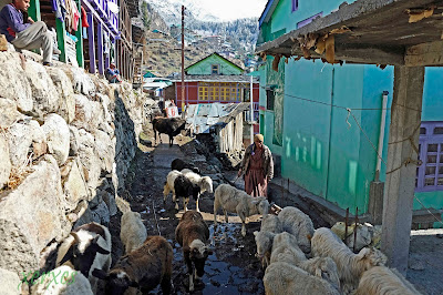
the melting snow made most paths slushy and wet, particularly if a herd of sheep or cattle had used it. There was mud everywhere and sometimes ankle deep. The village paths everywhere were veritable streams and it was important to have water resistant boots  and carry a spare set of socks all the time.
Snow, solitude and bare trees
March in the Valley is beautiful, the Great indian Tourist is yet to descend in hordes, there is a lovely biting nip in the air, there is solitude to be found off the beaten track 
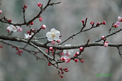
and the people are not so busy yet and have the time to be friendly.  Bare plum, apricot and apple trees strech their arms out to snow covered mountains over which huge Griffon and Golden eagles soar effortlessly.  

Tuesday, 19 April 2016

Solitude - The Great Himalayan national Park and Tirthan.

Relatively Untouched
Getting away from the madding crowd seems nearly impossible in these crowded times. Most trails and treks are virtual highways with a line of 'trekkers' like marching ants going to and fro.  Thus when I find a spot of seclusion I truly savour it, these are getting more difficult to find.    In my constant efforts to get far from the madding crowd, in mid-March 2016 I did a week's trek to the Great Himalayan Park.


The upper reaches of the Tirthan Valley
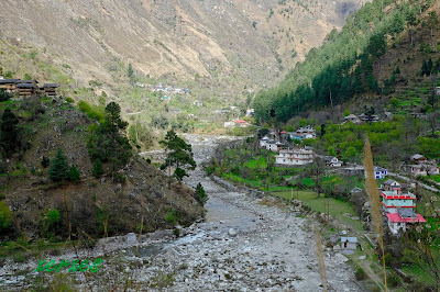
The path to the Great Himalayan National Park (GHNP) still remain relatively untouched, possibly due to the fact that Manali nearby has a greater draw, also that reaching the Tirthan Valley is still only possible by State run buses or private transport. 


Gushaini - where the trek trail starts
An overnight bus journey (aah the convenience of a Volvo!) got me from Delhi to Aut, about 60 kilometres short of Manali.  From Aut it is an hour and a half by taxi to Gushaini, the place where the trail to the Himalayan National Park starts. On arrival I was greeted by unseasonal heavy rains and everything was wet.  It was cloudy with intermittent showers and bits of bright sun peeking out.

The greens of spring at Raju's Hut
At Gushaini I had made arrangements to stay at Raju's Hut, a homestay, one of the first in the area.  They offer warm hospitality and three meals in the package.
 
Acclimatising in terraced fields
I spent the first day acclimatising, having ascended from sea level to1400 metres in 24 hours, acclimatising meant climbing the hill behind slowly, admiring the view and gently getting my breath under control. Walking up the mountain, I saw quaint houses, mostly large wooden structures surrounded by terraced fields and orchards.
The Temple in Bandal and the mountains of GNHP  
At the top of the hill I reached the temple in Village Bandal. the temple was locked and a local told me that it was open to and meant only for the benefactors who built it, I wonder?   Back before dark to a trout dinner and an early night.

My crew
On the first day I also made arrangements for a guide, cook and porter for the GNHP trek.  There are government rules regarding this and one cannot trek into the Park without a guide.  It's a good cause though, the cost is not much and it gives the local people an income. I engaged a guide, cook and porter, young boys all. 
 Distributing loads between Lal Chand, the cook and porter, and ensuring that we had adequate food and supplies, they would help me over the next three days.  
Lal Chand and I on the Trail to GNHP
My guide, Lal Chand, was a young boy, supremely fit, he could carry a load three times mine and prance light footed ahead while I trudged along behind him. Here he props me up so that I don't fall from exhaustion in front of the camera!!
A Shepherd and his flock on the the track to GNHP
It rained almost throughout the walk to the park and so it was not possible to use my camera most of the time. I took this picture during one of the rare pauses in the rain. The goats have long coarse hair which is used locally for warm clothes.  Leopard and bear are predatory on the goats, hence the huge local sheepdogs, mastiffs of a sort.

Gates of GNHP
 I took this picture on the way back, it was pouring on the way in.  The walk to the main gates of GHNP is about 12 km from Gushaini village, by the time I reached the gates it was raining a deluge and so Lal Chand and I had to take shelter in the forest hut nearby (seen in the background). We had to wait about two hours for the rain to reduce a bit, so we passed the time in heating some water for a Cuppa Noodles on a wood fire.


Rolla Camp at GNHP - 2050 metres
As soon as the rain abated we quickly walked to Rolla camp about 3 km away. There were beautiful sights along the way but the rain kept our heads down and cameras away. This was our destination for the night. I had intended to stay in a tent for the two nights I was there but it was so wet due to the rain, that I quickly managed to arrange to stay in one of the two forest huts here. After we set everything out to dry in the hut, the cook made dinner for me, dal, vegetables, rice and chappattis with some pickle was the fare. having done with dinner went to bed early, snug in my sleeping bag, as there was no electricity and I needed to conserve my torch batteries.
Icicles in the grass
It was cold that night, very cold, and by morning water in the grass had frozen. 
The temperature was about 4 degrees Celsius when I went out in the morning. There was no hot water at the 'Rolla Hilton', so I washed up in the crisp cold of the Tirthan River a few metres away, invigorating.
The view on the way to Shilt Hut
Next morning it dawned dry but very misty and since I had only that day to climb, after a breakfast of parathas, egg and pickle, Lal Chand and I set out for Shilt Hut, a shepherd's hut at about 3100m. This was my intended destination for the day and meant about four hours climb (as little as two hours for the very fit).  The Hut is set in a very pretty meadow from where one gets lovely views and photo ops of the snow clad mountains in front. I had been here in 2014, and on a bright and sunny day.
Monal tracks in the snow
But this time, due to the unseasonal rain, it had snowed very heavily over the last few days, this snow had turned to ice. The result was that from about 2500 metres onwards we were walking along a very slippery path of ice and wet mud. I had many birds sightings, the highlight being a Monal male, an absolutely gorgeous iridescent splash of colour in the trees some distance away.  A startled Bharal (mountain sheep) dashed past me so fast that I couldn't even get my camera up.

Snow Clad and Misty Mountains
The vegetation was mainly pine on the exposed hill sides, with the water courses having a lot of other vegetation. As one goes into the pine forests the bird life reduces. As the guide told me, pine trees restrict other vegetation  and therefore the food for birds is limited.  The beautiful view I had seen in 2014,  
was  obscured by clouds this time.  However the clouds amongst the trees and mountains have their own allure.
Heating lunch at Durunga Thuch near Shilt
After slipping and sliding for the last hour, at about 2700 metres we decided to stop climbing for Shilt, it was disappointing as Shilt was about half an hour away.  I took the decision for two reasons, one it had become dangerously slippery and would be more so near the exposed top, and without specialised climbing gear. Secondly it was getting late and I didn't want to be on the slippery mountain side after dark. Valour deferred to discretion and I took a decision to turn back after lunch. Lal Chand and I had carried parathas which we had intended to eat at the hut, we heated these in a wood fire under a rock overhang.

Wooden Swirl
As we turned back a bit early, I had time on hand to photograph the joys of nearly untouched nature around, toadstools, dead trees, plants. By evening there were few birds and in the cold, almost no visible insects.
Waterfall at Rolla
Just above Rolla camp, about 500metres away, there is a beautiful waterfall. Here the path splits into three distinct tracks, going North East is the long trek into the higher mountains of the Park.  North is Shilt and beyond, whereas South is the climb to Khorli Pohi, the breeding area of the Monal and accessible only by special permission from the forest department. I decided to walk down the path for a kilometre and see this waterfall on the upper Tirthan River.  
Mossy Rock in a stream at GNHP
Regrettably the next day I had to return. The day was clear but cloudy, we had intermittent drizzle and sun on the way back. We had initially planned to take a longer, more scenic route back over a mountain, however Lal Chand told me that this would be very slippery due to wet mud, though I suspect it was more because he wanted to get back early to his village after leaving me at Gushaini.
Rhodendron Tree in the Park
The way out allowed me to see a lot more that on the way in.  This lovely rhodo tree is between the Park gates and Rolla Camp.  The Rhodos had begun to bloom.

Rhododendrons
The Rhodos are a brilliant, difficult to photograph, crimson. Unlike Sikkim where Rhodos are in many colours including pink , mauve and white, here they grow only crimson. All rhodo trees had buds, some had flowered.
Chandi Devi's Hut
Fondly known as 'Buddhi', Chandi Devi is the only human living permanently in the Park.  The hut is an absolute marvel of harmony with nature.  It is built on three levels, at the lowest is where her animals live, goats and sheep; also where she has four beehives inside to which the bees have access through tiny holes in the wall. In the middle is her living area and under the roof is her cooking area.

Chandi Devi emerges from her hut
She is a feisty lady, living on her own, she claims to be the most photographed denizen of the Park!!!  The forest department is now trying to relocate her outside the Park which she stoutly refuses.  Her children support her partially.  Notice the holes for the bees on the walls on either side of the lower door. See more pictures of her and the other wonderful people I met, in my blog here The People of Tirthan Valley
Hippo Rock
Just outside the gates, there is a large waterfall and bridge, in the water here is a rock that looks like a hippo asleep in the water.  There is a tiny shrine 
nearby which is revered by trekkers.
Rhododendrons viewed from Darakhali
About two kilometres from hippo rock is Darakhali mobile point. This is the highest point before the park, it has a wooden shelter and view.  It is supposed to be the last place before the park where one gets a mobile signal.  Notwithstanding this, there is a profusion of bird life and plants, including these rhodos here.
The Temple at Ropa
On the way out I could only photograph it from the window of the teahouse I was taking shelter in.  However on the way back it was open and clear.  This seemed relatively new, but as is the case in most temples here, it was locked and I could not go in.
Terraced fields and orchards on the hill side
The path all along follows the Tirthan River, sometimes low and crossing it just before the Park.  Since time immemorial water has been the draw for civilisation, it is no different here.  There are huts many hours walk from the nearest road head.  almost always the huts and villages have terraced fields where the harsh winters allow only one or sometimes two crops.
Mountain Eirie
I found huts perched at the most impossible heights and locations.  Considering that everything has to be carried on human backs, most houses are made of local resources.  However now one finds Steel and cement increasingly being used. Some houses are many hours walk  away. I saw a group of young ladies chatting and walking, each had a  sack of about 20 to 30kg of flour on their backs. This is a weekly chore.
Back at Gushaini
The walk out of the Park took us almost double the time as I stopped for a lot of photography which I had missed due to the rain on the way in. I reached Gushaini at five that evening, settled accounts with Lal Chand and the crew and bid them farewell, they had done me well. back to Raju's Hut and re-organising myself for the next day. mainly camera battery charging as there had been no charging in the park for three days.

Ambassador over here?
At Raju's Hut I found this old car bonnet next to the place I was staying, it was miles from the road and must have been carried here by hand. Incongruous but elegant it was a nice sight. 
Buzzy Bee
When the sun came out there were bees everywhere, different shapes and sizes.  Honey is a major produce here.

Apple Blossoms
Spring was here, as was evident in the blossoms, birds, bees and butterflies. When the sun came out the next day the plants were abuzz with activity.

Grey Bushchat 
There was a lot of bird life on the property, specially along the river where I saw many birds including a shy crested kingfisher.
Beehive in the bungalow
 At the place I was staying, there was a gap in the planks of the wall, bees laden with pollen had made this into a handy hive. 

The clouds descend
Each day, at around noon, the clouds would descend and there would be a passing shower.  The clouds lend a mystique and atmosphere to the mountains.
Pine Cones
The pines were flowering and cones were emerging to disgorge their seeds on the ground.Pine trees discourage any other plants from growing nearby, besides the pine resin discourages insects,  hence one finds very few birds or insects in a pine forest.


Snow Clad Mountains
The continuous rain made it very cold, and the higher reaches were covered in snow all the time that I was there. The snowfall in spring made the weather delightful when it was sunny, but very cold when it got cloudy or it rained.

Waterfall above Sai Ropa
It is a very pretty spot that is reached after a short up hill walk through a few villages.  The route to the waterfall was blocked by 

Anjali
She was all of six years old and very aware.  I met her mother, sister and her at a village a little distance away from a waterfall above Gahidar Village (near Sai Ropa). She was absolutely confident and a chatterbox, she walked with me for about an hour to the waterfall and back.  She of the impish smile and vanity in her hair. See my link The People of Tirthan Valley for more pictures of Anjali.
Anjali's House
set among verdant fields of wheat, there was terraced cultivation everywhere.

Lower Tirthan Valley
From Gushaini downstream, the banks of the Tirthan are burgeoning with 'resorts' and spas, I am told that people from the plains have leased land from the villagers and built huge resorts.  It is only a matter of time before the ubiquitous 'Volvo' rolls in. But that is another story.

The tranquility and solitude of the upper reaches of the Tirthan River are hard to find today.  An anonymous poem describes it beautifully:

"Serenity flows through the natural world
Listen and you can hear
the beating of your own heart
and deepening of your breath
in rhythm and connection with
the powerful tranquility of creation
that becomes fully alive in you
as you return to the roots of your being."